

Cloud cover limited the value of satellite remote sensing for the period immediately preceding our departure. To compensate for the lack of broad scale context, we chose to occupy a set of sections spanning the northern and central basins (north of the Jabuka Pit). R/V Knorr sailed from Ancona, Italy, at 16:00 on 31 January 2003 into a strong, developing Bora that brought 4-5-m seas shortly after leaving the harbor. Although we had hoped for a strong forcing event, the first one began a little too early causing the science party to ramp up under demanding conditions.
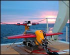
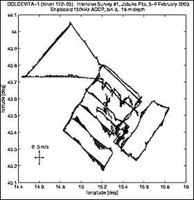
Several of the sections reoccupy lines historically sampled by investigators from IRPEM-Ancona, with additional lines sampling from the Po delta to Perec and traversing the mid-basin southward to the Jabuka Pit. We executed these sections using our Trisoarus towed profiling vehicle and, in some locations, the Bio-Optical Profiling package (BOP). Chemists and biologists from IRPEM, the University of Zagreb, and USC analyzed regularly spaced surface samples for pigment and nutrient concentrations and phytoplankton throughout this initial survey.
The sections revealed typical wintertime conditions, with little or no vertical stratification (except along the Italian coast) in the shallow northern basin. Farther south, profiles sampled deep mixed layers with Levantine intermediate and northern Adriatic deep waters below. Interesting features included:
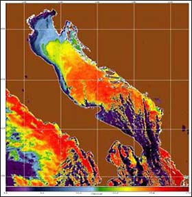
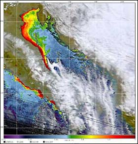
• A filament of Po River water that extends off the Italian shelf south of Ancona
• A plume of Po River water that covered a large portion of the northern basin, probably advected off the shelf during a recent Bora
• A prominent, compensated front south of Istria
• The mid-Adriatic filament, formed where the East Adriatic Current (EAC) turns eastward, leaving the Croatian coast and following the northern flank of the Jabuka pit.
The along-basin section revealed two distinct dense water pools and provided evidence supporting the idea that northern Adriatic deep waters form along the Croatian coast, perhaps south of the Istrian peninsula.
By the end of the initial survey, winds had shifted to Sirocco, blowing from the southeast. We chose to conduct intensive surveys of the mid-Adriatic filament during this period, sampling its eastern side, where it leaves the Croatian coast. A combination of an intensive cross-filament grid pattern, a series of sections radiating from the coast positioned north and south of the feature, drifters and a hydrographic/optics section are all used to investigate the dynamics governing the separation and to quantify the portion of the EAC that turns westward to follow the bathymetry. Preliminary examination indicates that most of the EAC turns to follow the northern flank of the Jabuka pit, bounded by what appears to be a strong, anti-cyclonic circulation lying to the north. One surprise is the observation of energetic small scale (< 10 km) variability, which is thought to be common during the stratified summer period but absent during the winter.
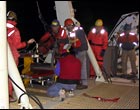
A forecast calling for a moderate/strong Bora sent us north to sample the front south of the Istrian peninsula. The feature lies beneath a strong, narrow wind jet, in a region of hypothesized wintertime deep water formation. We arrived at the survey site on the afternoon of 11 February, immediately deploying a bottom-moored 5-beam ADCP, followed by an array of 13 drifters (including optical, mini-met and thermistor chain equipped units) spread across the upstream end of the Trisoarus sampling pattern. Two 16-hour Trisoarus surveys followed, sampling the front through the Bora's peak. During these surveys, we found a strong, vertically-oriented, density-compensated temperature-salinity front. The front was typically less than 1 km wide and marked by a band of water denser than that found to either side. We believe that this is evidence of cabbelling, where nonlinearities in the equation of state can lead to the production of mixed water masses that are denser than the water masses from which they originated. The second survey captured dense waters spreading across the bottom, while a third survey (currently under way) occupied during a period of weaker winds, reveals pronounced tilting of the (formerly vertical) frontal interface.
Another strong Bora, forecast to begin on 16 February, offers an ideal opportunity to sample the plume of Po River water that extends into the northern basin. Following a fourth occupation of the Istrian survey, we plan to relocate our resources to focus on this feature. The winter Dolce Vita cruise will conclude with a reoccupation of the section running lengthwise down the basin, designed to investigate changes wrought by the passing of three significant Bora events.
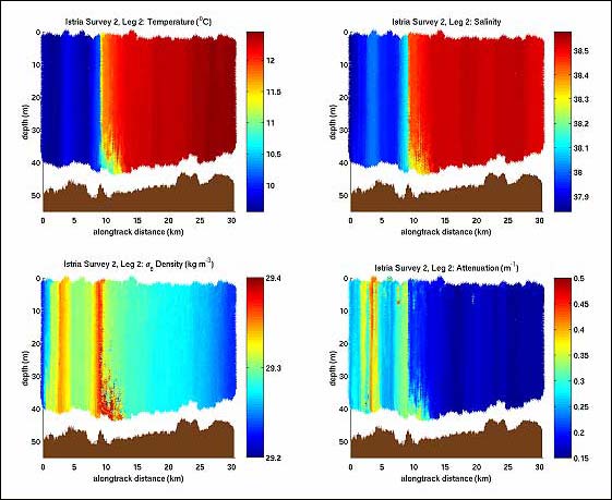
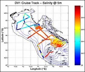
Temperature (UL), salinity (UR), density (LL), and light transmission (LR) for a section (north to south) across the Istrian front. The section was occupied during a period of strong wind forcing. There is little density contrast across the nearly vertical, compensated temperature-salinity front (cold/fresh to the north, warm/saline to the south). A narrow band of anomalously dense water sits at the frontal interface, widening as it approaches the bottom. |